






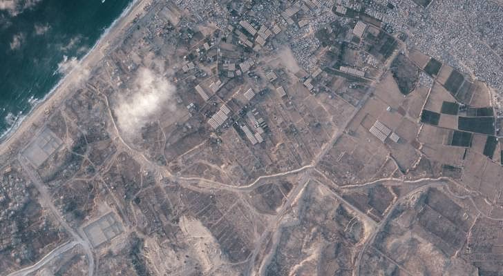
Recent satellite images, published by international sources, show the Israeli army constructing a massive earthen barrier exceeding 23 kilometers in length deep within the Gaza Strip. This field move reinforces the separation between areas the army has brought under its control and densely populated Palestinian residential areas, indicating a new geographical division strategy for the Strip.
According to media reports, this barrier extends along a path that has become known as the 'Yellow Line,' a field division that places about half of the Gaza Strip's area under direct military occupation control. The movements are not limited to earthen berms but also include the construction of wide military roads and the expansion of existing routes to facilitate the movement of vehicles and soldiers between different axes.
Field data derived from images and reports indicate widespread bulldozing operations that have affected vast areas of agricultural land that constituted a food basket for the residents. Satellites also detected the establishment of fixed military sites and bases on the ruins of destroyed areas, reflecting a trend to transform these points into permanent strongholds for military operations.
These fundamental changes in the Strip's topography extend from the city of Rafah in the far south to Beit Lahia in the north, where landfilling and geographical reshaping operations continue at an accelerated pace. Through these measures, the occupation army seeks to change the features of urban areas and civilian facilities, under the pretext of dismantling infrastructure used by resistance factions in their operations.
Ambiguity remains regarding the 'Yellow Line' drawn by these transformations, as its borders have not officially appeared in any draft ceasefire agreements or political statements issued by Tel Aviv or Washington. This absence of official clarifications leaves the actual path of the barrier open to continuous field expansion, away from international oversight or political understandings.
Field sources reported that the areas adjacent to this new barrier and the associated military lines have become definite death zones, where Palestinian civilians are prohibited from approaching. Anyone attempting to reach their land or home near these berms faces the risk of direct shooting, which deepens the displacement crisis and reduces the living spaces available within the Strip.
As this barrier continues to expand and the map of Gaza changes day by day, debate escalates about the nature of these measures and whether they are merely temporary security arrangements imposed by war conditions. However, the scale of construction and the type of military bases established suggest that we are facing a long-term reshaping process of the Gaza Strip's geography, aimed at creating a new internal border reality that tears apart the unity of the Strip's territory.
The view from above is clearer; new lines cut through the land, military routes expand, and an earthen barrier extends for tens of kilometers inside the Gaza Strip.
شارك برأيك
Satellites detect 23 km Israeli earthen wall dividing Gaza Strip