


The Arab territories surrounding occupied Palestine are witnessing an accelerating Israeli military and settlement creep, exceeding traditional control boundaries through strategies ranging from temporary military lines to fixed strongholds. Recent reports reveal systematic movements to shrink the areas available to Palestinians, Lebanese, and Syrians, as logistical routes and earth barriers transform into new geographical borders, imposing a fait accompli on the ground.
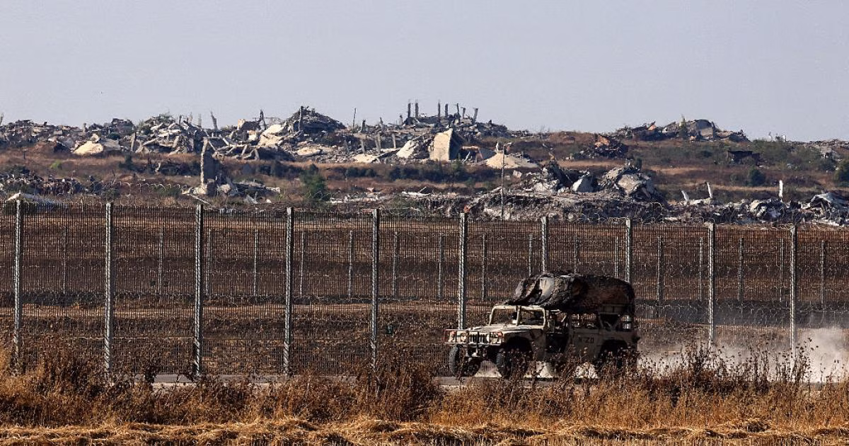
In the Gaza Strip, what is known as the 'Yellow Line' has transformed from a temporary arrangement following the October 2025 ceasefire into a physical barrier longitudinally dividing the Strip. Satellite analyses indicate that Israel now effectively controls an area ranging between 54% and 60% of the Strip's total area, with political directives issued to expand this percentage to 70% through extensive demolition and bulldozing operations.
Satellite images show yellow concrete blocks penetrating up to 940 meters deep into the Strip's territories, especially in the areas of Rafah, Khan Yunis, and Shuja'iyya. The occupation forces have constructed 48 military sites connected by a complex logistical road network, including the upgrading of military bases in Jabalia and the establishment of buffer zones 300 meters deep behind the declared lines.
On the northern front, Israel has adopted a similar model through what it called the 'Forward Defense Line' within southern Lebanon, extending from Naqoura in the west to Shebaa Farms in the east. Field sources now confirm that military movements have exceeded this line, reaching the areas of Nabatieh and the vicinity of the Litani River, where the army announced its control over the strategic Beaufort Castle for the first time since 2000.
Official Lebanese data indicates the massive destruction caused by Israeli operations, with thousands of airstrikes and hundreds of systematic demolition operations of residential buildings. This pattern of destruction aims, according to observers, to create a geographically depopulated area that ensures long-term security control beyond the concept of transient military operations.
In the West Bank, settlement expands like a geographical 'tumor' supported by massive government funding exceeding $350 million for the establishment of 61 new de facto settlements. This plan focuses on sensitive areas in the Jordan Valley and the southern Hebron hills, with the aim of creating geographical continuity between existing settlements and isolating Palestinian communities into fragmented enclaves.
Jenin city stands out as a stark example of this transformation, where the Israeli army established a permanent military post near its camp, a first of its kind within areas classified as 'A'. This step is accompanied by military confiscation orders for lands in the Jabriyat neighborhood, indicating a clear intention to transform temporary military presence into permanent bases controlling the heights overlooking the city.
Human rights reports reveal the use of 'military confiscation orders' as a legal tool to accelerate the legitimization of settlement outposts and to construct bypass roads connecting them to the Israeli interior. More than 140 military confiscation orders have been documented over the past two years, the vast majority of which were used to serve settlement projects and convert abandoned bases into inhabited civilian settlements.
In occupied Jerusalem, 'silent annexation' operations are underway through pushing plans to build more than 33,000 new housing units in East Jerusalem, targeting the neighborhoods of Sheikh Jarrah, Silwan, and Batan al-Hawa. These projects, such as the 'E1' project, aim to completely isolate Jerusalem city from its Palestinian surroundings in the West Bank, and to transform Arab neighborhoods into isolated islands amidst a settlement environment.
Occupation authorities in Jerusalem use multiple tools including home demolitions, family evictions, and moving military checkpoints deeper into the West Bank to change the municipal boundaries of the city. Human rights organizations have monitored the demolition of dozens of homes in the Bustan and Sur Baher neighborhoods, coinciding with the allocation of huge budgets to protect settlers who are being planted within densely populated Palestinian neighborhoods.
On the Syrian front, Israeli forces have exploited field changes to strengthen their military presence behind the 1974 disengagement line, especially around Mount Hermon and the Quneitra countryside. Occupation patrols conduct periodic incursions into villages in the Yarmouk basin and the western Daraa countryside, where they establish temporary checkpoints and carry out search and arrest operations targeting Syrian citizens in those areas.
Reports from Quneitra indicate that Israeli incursions are no longer limited to observation but have included control over farms and villages such as 'Abu Madhra' and 'Al-Asha'. This undeclared military expansion aims to create a security sphere of influence that guarantees Israel freedom of movement and rapid intervention deep into Syria, away from previous international agreements.
These simultaneous movements on various fronts reflect a comprehensive Israeli strategy to redraw the region's map to serve its security and demographic interests. By transforming 'temporary lines' into a tangible reality, Israel succeeds in seizing thousands of square kilometers of Arab land amidst international silence or mere condemnation statements that do not change the reality on the ground.
In conclusion, analysts believe that what is happening is a process of 'geographical engineering' aimed at ending any future opportunity for the establishment of a contiguous Palestinian state, and securing Israel's borders through buffer zones carved out of the sovereignty of neighboring countries. The biggest challenge for Palestinians and Arabs remains how to confront this creep that recognizes neither international borders nor signed agreements.
The occupation is moving in one direction towards shrinking the available space for Palestinians and Arabs, by establishing areas of influence that gradually transform from temporary military measures into a permanent settlement reality.
שתף את דעתך
Maps of Silent Creep: How Israel is Redrawing the Borders of Control in Gaza, the West Bank, Lebanon, and Syria?